- Free State Online
- Departments
- Office of the Premier
- Agriculture & Rural Development
- Education
- Health
- Coorperative Governance & Traditional Affairs
- Public Works & Infrastructure
- Police, Roads & Transport
- Social Development
- Sport, Art, Culture and Recreation
- Economic, Small Business Development, Tourism & Environmental Affairs
- Human Settlements
- Treasury
- Municipalities
- Entities

Towns
Reitz
History and Background
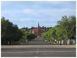
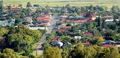
Reitz is the principal town of the area and economically the strongest. Lying almost halfway between Bethlehem and Frankfort on Route 26, Reitz is described as a peaceful village. Reitz was originally known as Singer’s Post. The town’s name was then changed to Amsterdam and finally, it was named Reitz, in honour of the Orange Free States President, Francis William Reitz, in 1899. It first became a municipality in 1903. It is a small Free State town which is a centre for the maize, wheat and cattle farmers of the area. Its biggest claim to fame is that it has the largest maize silos in the southern hemisphere.
Trade and Services
Reitz has a well-developed CBD in the centre of Reitz with a variety of retail businesses and related services including agricultural suppliers, wholesalers, retailers, general dealers, hair dressers, funeral parlors, pharmacies, bakeries, professional service providers and many more.
Apart from the above formal businesses, a substantial number of business activities are also to be found in Petsana, including spaza shops, vegetable shops, backyard repair shops, panel beaters, car washes, builders and so forth.
Industrial
Reitz has two industrial areas situated directly to the north of Petsana and Reitz respectively where a variety of light and heavy industries can be found. Most of these industries are however related to and in support of the agricultural sector.
Petrus Steyn
History and Background
Petrus Steyn, named after a leading local farmer of the time, was founded in 1912. It is situated near the large hill Elandskop, the scene of many a skirmish between Boer and Brit during the Anglo-Boer War.
Research has indicated that Petrus Steyn is the Free State town highest above sea level, at 1 702 meter above sea level and is dominated by one of the biggest co-operative grain silos in the Free State. The Renoster River has its source near the town.
Trade and Services
Petrus Steyn has a well defined CBD. Businesses found within the CBD include the co-operation, a supermarket, retail shops and general dealers and liquor stores, a hotel and hair dressers. Other services of interest include financial institutions, medical doctor’s practices, a pharmacy, an estate agency and funeral houses.
Mamafubedu accommodates quite a number of formal businesses, which is mostly situated at the entrance to Mamafubedu. There are quite a large number of residential sites used for mixed uses such as businesses, taverns, funeral parlours, fuel depots and spaza shops. These properties have not been rezoned as such.
Industrial
One of Petrus Steyn’s largest assets is the grain silo situated to the northwest of the town next to the railway station. The silos have the largest storage capacity of 102 000 tons in the Lindley district. According to the co-operation, approximately 25 000 tons of maize are stored during May to August, whilst approximately 35 000 ton of wheat are stored during December to February each year. The industrial area itself is completely served and has good access from both external roads and the railway line, but is currently completely underutilized. There is ample land available for expansion should the need arise. Several other enterprises are situated in the town itself which include a warehouse, engineering works, a mill and bakery, 2 potato wash facilities, a fuel depot and various light industrial workshops.
LINDLEY
Lindley was laid out in 1875 on the farm Brandhoek and proclaimed a town in 1878. Lindley is named after a missionary, Daniel Lindley, an American Presbyterian minister of the Voortrekkers. Historically notable was the Battle for Yeomanry Hills which took place during May 1900 between British and Free State forces.
The farm Doornkloof of famous Voortrekker leader, Sarel Cilliers, is also in the district, forming today the national headquarters of the Voortrekkers youth movement.
Trade and Services
Lindley has a well defined CBD consisting of several businesses linear along the main road to the north and south of the CBD. Ntha has not yet a well defined CBD although a concentration of businesses exists in the township. A need exists for the development of the large business site adjacent to the access road to Ntha to serve as an activity or business node.
Industrial
No provision is made for light industrial sites in a designated industrial area in Lindley. A definite need exists for sites of this nature. A few light industrial sites were provided in Ntha along the main collector roads through Ntha.
Arlington
History and Background
Founded in 1930, the village of Arlington is supported by a very strong agricultural district, especially cattle studs for the Simmintaler, Simbra and Angus breeds.
Trade and Services
Arlington has a well defined and accessible CBD adjacent to the major road between Bethlehem and Steynsrus. Leratswana has a small business activity node consisting of community facilities and shops adjacent to the access road. The business areas described indicate limited growth potential. Arlington has no industrial sites available due to the lack of available land.